Wednesday, October 21, 2020

Avalahalli Lake Report 2020


Summary

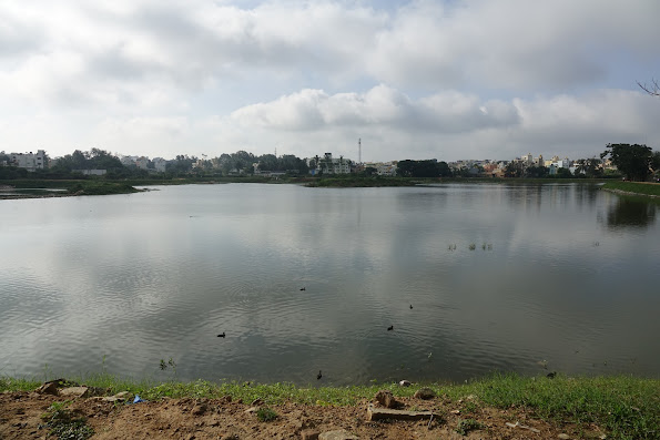
Alahalli Lake, also called Avalahalli Lake, is on 23 acres with a walking path of 1.3km.  It is located in the southern part of Bangalore next to Amruth Nagar Main Road and Nandi Gardens Apartment Complex. It was observed during our visit on 29th August 2020 that the lake was frequented by local residents. The lake was filled with water and many birds were observed! 

This is mostly rain fed lake with less than 20% of sewage entering the lake as an overflow during the rainy season. A diversion drain which diverts the sewage from entering the lake is provided and connects all the inlets and takes the sewage to the outlet of the lake. There is an island at the center of the lake. There are two old wells at the outlet.  One of the wells is functioning and water is used for domestic purposes by the community apart from drinking  It was interesting to note that the water level in the well was higher than the lake water level. The other well was non functioning and was filled with garbage.


BBMP started rejuvenating this lake in 2017. They have completed phase 1 of rejuvenation. The lake has been fenced all around. There are 4 inlets and an outlet. There are two wetlands provided to two of the inlets.  There is a walking path all around the lake.  


Location

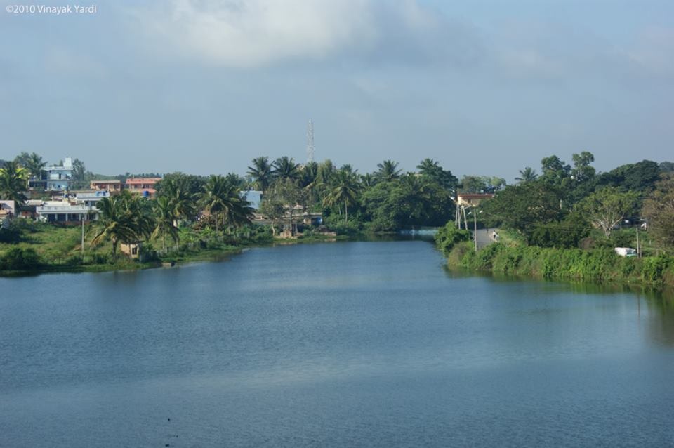
Upstream and Downstream lakes


A’         A

Conceptual Section AA’


Overview and Observations

Alahalli Lake is shared between two survey numbers of Alahalli and Gollahalli villages, Bengaluru.


Lake Area

23 acres

STP 

No STPs

Wetlands

2 wetlands just after the inlets

Upstream lake

Kembathalli Lake

Downstream lake

Vaderahalli Lake


Alahalli Lake & Neighborhood Development Trust (ALNDT), the local corporator K. Somashekar, Pavitra Foundation, PROMAC Industries, and a few residents nearby have put efforts in the direction of rejuvenating the lake. In 2015-17, together citizens have spent about Rs. 20 lakhs for de-weeding, constructing a 100 meter walking path, repair and maintenance of fences, operation and maintenance. 


BBMP started rejuvenating the lake in 2017.  There is a walking path around the lake. It has two gates. The main gate is located on the North Western side.  There is a small gate for villagers to use which is located on the Eastern side.


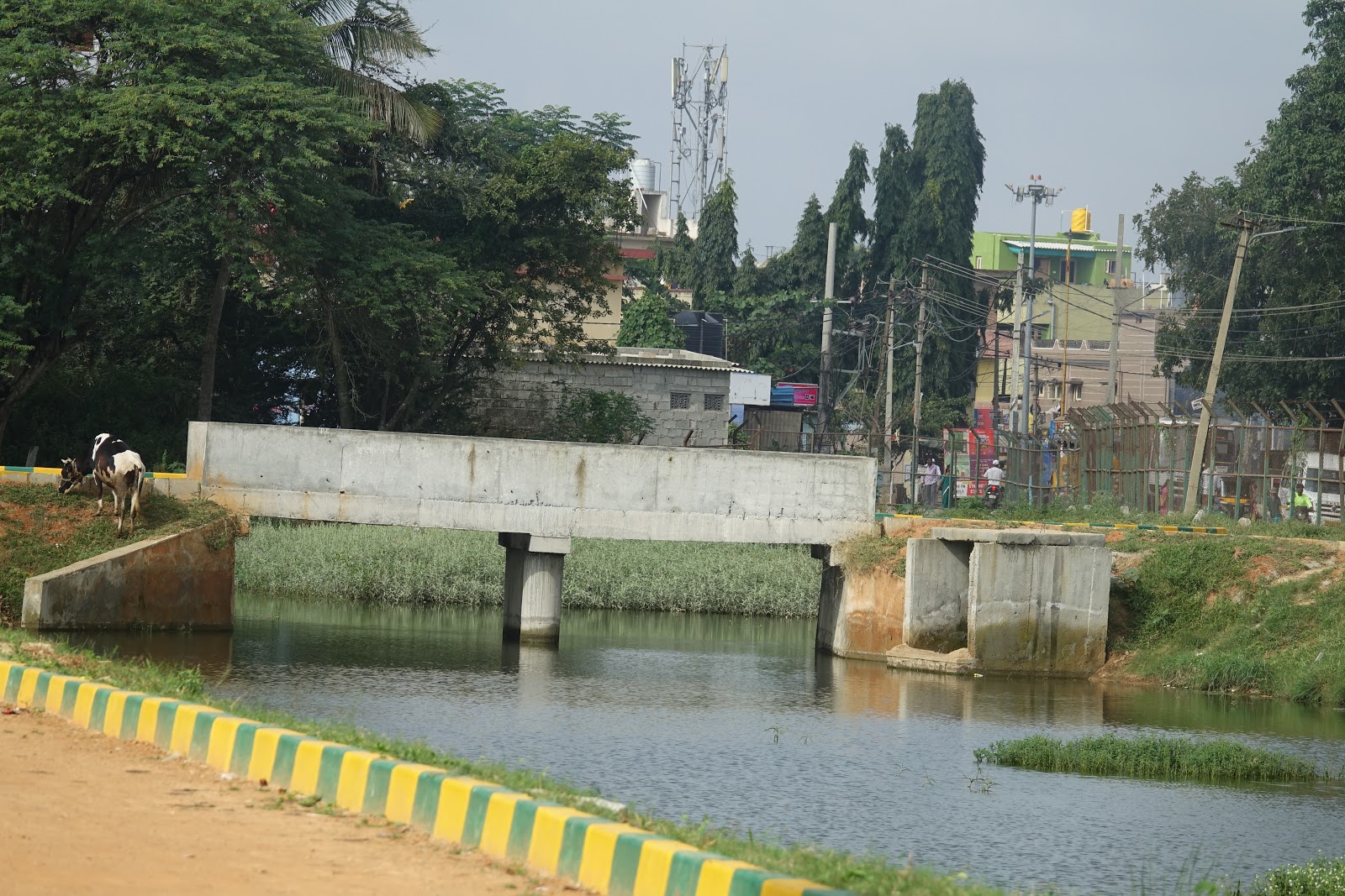
There are 3 inlets to the lake.  Rajakaluve being one of the main inlet is situated at the North East side and two medium size drains in the East side of the lake.  There is one outlet at the South end of the lake. The rajakaluve and one of the East side drain water enter the lake through a wetland. The inlets have a small wall built to stop the sewage inflow from the drains into the lake directly. There is a sewage diversion drain connecting all the inlets joining the outlet.


The design of the lake is like a soup bowl. The depth of the lake from inlet to outlet varies from 1m to 3m. The wetlands near the inlets have the depth of 2-3 feet. There was supposed to be wetlands in front of all the inlets, but currently the wetlands are provided  only for 2 main inlets.


There is a graveyard located on the North East side of the lake.


It was observed that the health of the lake is better from years before the rejuvenation. Only during the monsoon, we were told the sewage enters the lake. The water from the inlets has a wall of 1-1.5 feet protecting the lake from sewage entry. Phase 1 of the lake rejuvenation has been completed by BBMP. They are awaiting Phase 2, when trees will be planted all around the lake. They are also planning benches, an inner fence around the waterbody, kalyani and a gym at the lake.


Livelihood activities such as  fishing, grass cutting and cow grazing is allowed at the lake. Deweeding and maintenance work is done by BBMP. It has one central island for the birds to have its own habitat.


LAKE-


  1. Inlets and outlets 


Inlet

Name

Description

Photos

1

Inlet 1- Raja Kaluve on the

North-Eastern side

Rajakaluve carrying storm water along with sewage is discharged into the lake. There is a diversion drain where some of the water gets diverted. 


The inlet has the wall which is one-one and half feet tall stopping the direct inflow of sewage water. When the water level increases during monsoon, it flows into the main water body through the wetland.

2

Inlet 2

East side

Another stormwater drain where the water passes through a wetland before reaching the lake.


3

Inlet 3

North Side

Overflow from Kembathalli Lake discharges directly into Alahalli Lake through a culvert without any treatment. .

4

Outlet 

Southern side

This water overflows into Vaddarahalli lake

This has an emergency exit for maintaining the water level not to rise above the bridge

(below image shows the emergency exit)


  1. Biodiversity-

In the second phase of rejuvenation by BBMP more trees and plants will be planted around the lake. Some of the flora and fauna observed around the lakes are documented below.

Trees and plants- There are mostly fruit bearing plants at the lake. The island of the lake has trees like Cashews, Jamoon etc. These were planted in Nov 2019. Around 40 plants and trees were planted on that island, but 32 of them have survived.


      Central Island Trees along the path


Around the lake there are trees like Bettada hunase, Cholle hannina mara, Ficus, Rain tree, Acacia and Banyan tree


Birds and Insects-

There were a lot of Coots found in the lake. Some of the other birds that were spotted are Purple moorhen, Bronze tailed jacana, Purple heron, Little grebe, Pond heron, Cormorants, Pond heron.


    Purple moorhen Coots


There were also dragon flies that were observed at the lake-


Cows at the lake-

Cows are allowed to graze at the lake.

Cow grazing


  1. Livelihood-

The lake provides livelihood for grasscutters, fishermen and workers-

Weeds being removed from the bund


  1. Wells at the lake-

There are 2 wells which are around 40-50 years old at the lake, one of them is a functioning well.  Both are located next to each other and near the outlet. Functioning well is used for domestic purposes by the community around the lake apart from drinking.

Old Functioning well


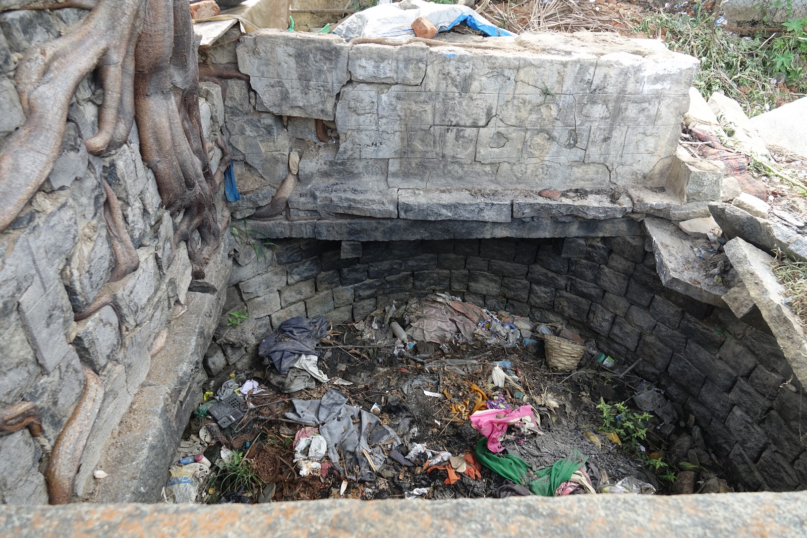
Non-functioning well


  1. Wetlands-

At Inlet one a Wetland of about an 1 acre treated the water before it enters the lake. The other wetland is about half an acre at the Inlet 2.  Few wetland species observed are Typha, Water Hyacinth, Alligator weed, Knot weed, Cyperus, Water lily.


  1. Timeline of the lake-


Year

Photo

Incidents

2008


It was under BDA and the lake had been put under a fence to protect from encroachment.

2010

Sewage started entering due to the population spike at the lake.

2014

Water hyacinth was at the lake, which was cleared by BDA and the people around in 2011.


Trust was registered in 2012


2015

The lake was filled with water hyacinth.

2017

Cleaning of the waterbody started. Deweeding in the waterbody. 5000 tons of weeds were cleared by citizens and an NGO called Pavithra Foundation.


It was handed over to BBMP. Hence the rejuvenation started. 

2019

During the rejuvenation of the lake. Sewage entry was stopped with the introduction of wetland

2020

Lake has finished with phase 1 rejuvenation. 


BBMP board at the lake


Contact Info

ALNDT contact ID- savealahallilake@gmail.com


References & Resources

1https://www.facebook.com/SaveAlahalliLake/ 

2http://bangaloremirror.indiatimes.com/bangalore/civic/alahalli-lake-shows-signs-of-life/articleshow/56281598.cms 

3http://www.deccanherald.com/content/587349/thanks-residents-alahalli-lake-cleared.html 

4http://www.thenewsminute.com/article/tired-government-apathy-bengaluru-residents-pitch-clean-alahalli-lake-54498  


Thursday, October 1, 2020

Kannamangala lake rejuvenated through Citizen-driven Participatory process


INTRODUCTION

Kannamangala lake, situated 7km from ITPL in Bengaluru East taluk, has been a fast growing residential area and has experienced drastic changes in ecology, land use and management over the past decade. Spread over 18 acres, this lake used to be managed by the neighbourhood and serve the villages of Kannamangala, Seegehalli and Doddabhanahalli as a main source for drinking water and for irrigation of their agricultural fields. 


Kannamangala lake, situated in Bengaluru East Taluk

Kannamangala lake in the context of the neighbouring agricultural lands, villages and apartment complexes.

The lake was neglected and exploited over several decades with indiscriminate release of sewage from surrounding residential areas. In addition, the lake became an area for dumping and burning of garbage. The lack of maintenance, desilting and drilling of borewells nearby, led to a shrink and drying up of the lakebed. The groundwater in this region also saw a steep decline from 300ft to 1000ft in a short span of time, putting the neighbourhood under a water-stress situation.

Realizing the importance of the lake as a biodiversity spot/urban park and to meet their water demands, the local citizens combined their efforts and took up the task of rejuvenating the lake. Through various meetings and in consultation with various stakeholders (ecologists, local community and engineers), a shared-vision and a strategic plan of action was drafted for the lake. 

In a little over a year of work, the lake has been given a new life. It is now brimming with water, with increased water tables in nearby wells and borewells, being used by the farmers. It is also home to a variety of flora and fauna and is being used by the local community as a recreational space. The revival of the lake is a prime example of what can be accomplished when the government and people work hand-in-hand. 


Historical imagery of Kannamangala showing changes in the neighbourhood, ecology, land use and management


THE LAKE, BEFORE - A DUMP SITE 

The lake bed had dried up as early as 2003. The lake had been receiving greywater from the nearby villages since the last couple of years. As a result of recent real estate development, the wastewater from the nearby apartments were also being discharged into the lake.

To meet the irrigation water demands, the farmers around Kannamangala lake were pumping additional water into the lake from an overflow drain located 3km away, connected to Yella Mallappa Shetty kere. Pipes have been laid by various other farmers also in the overflow drain of Yellamallapa Shetty kere to draw water and meet the demand of their agricultural lands. The water which is pumped into the lake is then indirectly used through indirect recharge, from wells and borewells. 

Pipes laid by various farmers in the overflow drain of Yellamallapa Shetty kere 
for drawing water for their agricultural lands 


The local farmers have been growing corn, paddy, millets (ragi), mulberry, a few ornamental plants (rose and other flowers) and some other vegetables (asparagus, broccoli, cabbage etc.). Additionally, the cattle herders use the lake surrounding for feeding their cattle.

LAKE NOW - A COMMUNITY SPACE FOR RECREATION, LIVELIHOOD AND WATER PROVISION 

The Kannamangala Panchayat, FORCE-GW and the Mahadevapura Task Force are behind the transformation of Kannamangala lake. (FORCE-GW is a Federation of RWAs, Communities and Establishments of Greater Whitefield, with a mission of making Mahadevpura a model suburb in Bangalore. Their aim is to promote harmonious community living and to implement green, environment friendly practices in the member communities. One of the objectives is also to work with neighborhood villages to improve their infrastructure, health and education standards)

A core team was established in order to create a vision for the lake and draft a plan of action. The revival process started in May 2018, when FORCE-GW and the gram panchayat agreed to help revive the lake and as the first task, clean up 400 tonnes of garbage that had been dumped into the lake.


The core team of people initially set up to actively participate in the lake rejuvenation process


400 tonnes of garbage being removed from the lake bed and being transported to a waste management site in Doddaballapur 


After conducting a survey of the entire lake and assessing the site, discussions were started with the locals to clear the encroachments from the lakebed, who offered full co-operation as they also understood and saw the value of the lake. Collectively, it was decided that water will not be pumped from the outflow of Yella Mallappa Shetty lake anymore. The Revenue Department then fenced the lake fully, ensuring to leave connections and pathways around for access to the farmlands only approachable through the lake site.

FORCE-GW took over the responsibility of the lake development in 2019 for a five-year period, through a signed agreement with the gram panchayat. After many discussions with engineers and experts, the lake was re-designed and work started to desilt the lakebed, rebuild and strengthen the bunds. This work was driven by a gram panchayat member Ravi (also a farmer) who organized a full team to carry out all the works and seamlessly managed it as he had close relationships in the neighbourhood to conduct any negotiations and had fond memories of the lake.


Desilting of the lake bed, and building bunds all around the lake being carried out

FORCE-GW closely worked with Biome as a knowledge partner, to understand the wetlands ecosystems; the design, sizing, location and useful plant species. Visits were made to several other lakes in order to understand lake biodiversity and the best practices for lake management. Islands were created in the middle of the lake to allow nesting for birds. 

FORCE-GW also brought in experts from Saytrees to understand the indigenous flora and fauna. With their help, the team created two Miyawaki forests through plantation drives. Around 5000 trees have been planted in and around the lake through several weekend programs, wherein local residents and volunteers participated. A vetiver expert was brought in from Coimbatore, who also helped with the design and plantation of vetiver on the lake bunds for strengthening it. 

While there was a seed fund to start off with the cleaning process, additional funding came through as contributions from individual apartments for specific activities of the lake rejuvenation process. 


Vetiver saplings being prepared for planting on the lake bund


Vetiver saplings being planted on the lake bund in order to strengthen them


Volunteeres and local residents participating in plantation drives around the lake


Volunteered and local residents participating in cleaning drives being 
conducted as a part of the lake rejuvenation


Today, this lake has become a biodiversity hotspot and a huge asset for the local communities, who not only use it for recreational purposes but also are able to meet their domestic water demands as the groundwater is now available at 300ft. The farmers are seeing the benefits as open wells on their agricultural lands have also become full and they are able to meet irrigation needs without pumping water from far-off sources. The borewell water level also impacts the water tanker suppliers. Tankers are filled near the lake and the water is supplied to neighbouring apartments and villas.

Work to improve the lake continues as funds come in to add additional features around the lake for recreation and conducting cultural activities. There are plans to construct a volleyball court, butterfly gardens and a children’s park. FORCE-GW members continue to meet for over two hours every weekend to chart out plans to continuously improve the lake. Several biodiversity walks are also being conducted in order to engage with the local community and create awareness about the need for improving the lake.


 Map showing the neighbourhood around the lake and the current design of the lake with wetlands, miyawaki forests, walking paths etc.

The lake is now being funded and maintained by an NGO, United way, which is helping various other such lakes to come back to life! FORCE-GW has also now been working to rejuvenate another lake close by and have successfully started a snow-ball effect in the neighbourhood.


All the stakeholders involved in the process of lake rejuvenation 


ELEMENTS OF A LAKE 

Lake bed

Kannamangala lake has been split into two portions, one on the north and the other on the south. 

Inlets

There are three inlets to the lake. Inlet 1 gets agricultural runoff from the nearby fields. Inlet 2 gets treated wastewater from the apartments and inlet 3 gets greywater from the village. 

Inlet with treated wastewater coming from the apartment blocks


Connectivity 

There is a 5m wide asphalt road around the lake which can be used by locals to travel from one side to another and to access their farmlands. A 3m wide pathway has also been made all around the lake.

Outlet

There is an outlet at the North of the lake. This is an old Kodi built years ago. Overflow of the water goes into nearby farms and further flows into a stream which joins another outflow stream of Hoskote Kere (located upstream of Kannamangla lake). 

Outlet towards the north end of lake, connecting to a drainage channel


Wetlands

There are two wetlands on the west and south side of the lake, which gets water from the 3 inlets. This is still under construction, but the plan is to set them up to act as natural filters and remove contaminants from the inflowing sewage water before entering the main waterbody.

Wetland 2, towards the west end of the lake, showing the partitions built for channeling water flow

Wetland 1, towards the south end of the lake


Graveyard

On the West between the two ponds is a graveyard. 

Borewells

There are three borewells around the lake. Two of them belong to the gram panchayat, while the other is being used by a local farmer for his agricultural lands.

Borewell in the lake bed


Open Wells

There are 3 open wells close to the lake, currently with high water tables. A beautiful Cannonball tree is next to the well on the west, a star attraction at the lake. 

Open well near the lake with high water table currently


Community garden 

The apartment complexes around have come together to manage a small vegetable garden, in an adjoining plot nearby the lake. These lands have been leased by individual families and are being taken care of by the local women, who are paid by the community. The harvests of which are used by the residents.

Women who work in the community garden


More photographs of the lake clicked during the 2020 monsoon can be found below. 


One of the Miyawaki forests planted around the lake bed with about 5000 trees.

One of the Miyawaki forests planted around the lake bed with about 5000 trees.
Agricultural lands around the Kannamangala lake


Lake, as of today (Aug 2020) showing the islands and the biodiversity of trees around

Picture courtesy: Force-GW, Biome Trust and volunteers


For more information, please visit www.kannamangalalake.com or/and write to them at Kannamangalalake@gmail.com

Contact Mr. Vincent Paul Raj for enquiring and procuring Vettiver on 98940 66303.